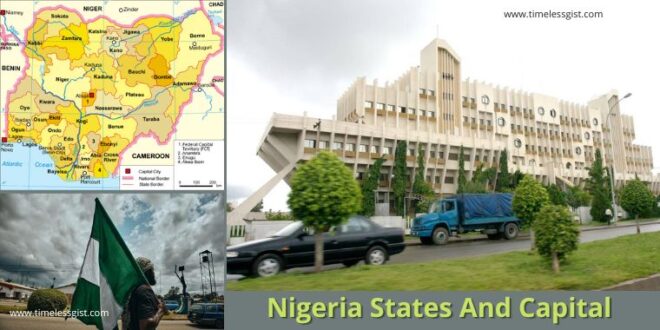
Nigeria states and capital, State and capital of Nigeria, 36 State And Capital in Nigeria, state and capital in Nigeria
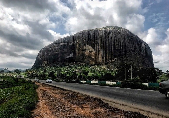
Nigeria is the most populous black nation in the world. It is home to the second-largest film industry on the globe whilst also being the fashion, technological and creative hub in Africa. Nigerians are known for their vibrant and friendly energy expressed through diverse creative expressions. One of the most recognizable sites is Zuma Rock, a 725m-tall monolith outside the capital of Abuja that’s pictured on the national currency. While Abuja is the Capital territory, it has 36 states which you will learn about in this article.
Also read: Who is Kanye West? – Why is Ye being Cancelled?
It covers an area of 923,769 square kilometres (356,669 sq mi), and with a population of over 225 million, it is the most populous country in Africa, and the world’s sixth-most populous country. Nigeria borders Niger in the north, Chad in the northeast, Cameroon in the east, and Benin in the west. Nigeria is a federal republic comprising 36 states and the Federal Capital Territory, where the capital, Abuja, is located. The largest city in Nigeria is Lagos, one of the largest metropolitan areas in the world and the second-largest in Africa.
Each of Nigeria’s 36 states is a semi-autonomous political unit that shares powers with the federal government, as outlined in the Constitution of the Federal Republic of Nigeria. Each state has its own constitution and political system.
Abuja is the capital city of Nigeria, in the middle of the country. The skyline of the city, which was built largely in the 1980s, is dominated by Aso Rock, an enormous monolith. It rises up behind the Presidential Complex, which houses the residence and offices of the Nigerian president in the Three Arms Zone on the eastern edge of the city. Abuja is the capital and eighth most populous city of Nigeria. Situated at the centre of the country within the Federal Capital Territory (FCT).
The Local Government Areas (LGAs) are subdivided into each state (LGAs). Nigeria currently has a total of 774 Local Government Areas (LGAs) in existence. Enshrine in the Nigerian Constitution, Nigeria has 36 states but not with supreme power, because the Federal Government has sovereignty over all of the states.
For addition of more states will require an amendment to the constitution which must be ratified by two-thirds of the states of the federation in order to become effective. The National Assembly can amend the constitution, but each amendment must be ratified by two-thirds of the states of the federation in order to become effective.
The creation of all the 36 states and capital in Nigeria occurred periodically, though not in a regular sequence.
Also read: 12 Cheapest Universities in UK 2022/2023
Below is the list of Nigeria’s 36 states, capital, and their slogan.
Nigeria States And Capital – 36 States – State and Capital in Nigeria
| No | State | Capital | Slogan |
|---|---|---|---|
| 1 | Abia State | Umuahia | God’s Own State |
| 2 | Adamawa State | Yola | Land of Beauty |
| 3 | Akwa Ibom State | Uyo | Land of Promise |
| 4 | Anambra State | Awka | Light of the Nation |
| 5 | Bauchi State | Bauchi | Pearl of Tourism |
| 6 | Bayelsa State | Yenagoa | Glory of all lands |
| 7 | Benue State | Makurdi | Food Basket of the Nation |
| 8 | Borno State | Maiduguri | Home of Peace |
| 9 | Cross River State | Calabar | The People’s Paradise |
| 10 | Delta State | Asaba | The Big Heart |
| 11 | Ebonyi State | Abakaliki | Salt of the Nation |
| 12 | Edo State | Benin City | Heart Beat of Nigeria |
| 13 | Ekiti State | Ado – Ekiti | Land of Honour and Integrity |
| 14 | Enugu State | Enugu | Coal City State |
| 15 | Gombe State | Gombe | Jewel in the Savannah |
| 16 | Imo State | Owerri | Eastern Heartland |
| 17 | Jigawa State | Dutse | The New World |
| 18 | Kaduna State | Kaduna | Centre of Learning |
Also read: Top 11 Richest Musicians in Nigeria 2022
| 19 | Kano State | Kano | Centre of Commerce |
| 20 | Katsina State | Katsina | Home of Hospitality |
| 21 | Kebbi State | Birnin Kebbi | Land of Equity |
| 22 | Kogi State | Lokoja | The Confluence State |
| 23 | Kwara State | Ilorin | State of Harmony |
| 24 | Lagos State | Ikeja | Centre of Excellence |
| 25 | Nasarawa State | Lafia | Home of Solid Minerals |
| 26 | Niger State | Minna | The Power State |
| 27 | Ogun State | Abeokuta | Gateway State |
| 28 | Ondo State | Akure | Sunshine State |
| 29 | Osun State | Oshogbo | Land of Virtue |
| 30 | Oyo State | Ibadan | Pace Setter State |
| 31 | Plateau State | Jos | Home of Peace and Tourism |
| 32 | Rivers State | Port Harcourt | Treasure Base of the Nation |
| 33 | Sokoto State | Sokoto | Seat of the Caliphate |
| 34 | Taraba State | Jalingo | Nature’s Gift to the Nation |
| 35 | Yobe State | Damaturu | Pride of the Sahel |
| 36 | Zamfara State | Gusau | Farming is Our Pride |
1. Abia State – Umuahia (God’s Own State) – State and capital of Nigeria
Abia State is a state in the South-East geopolitical zone of Nigeria, it is bordered to the north and northeast by the states of Enugu, and Ebonyi, Imo State to the west, Cross River State to the east, Akwa Ibom State to the southeast, and Rivers State to the south.
Abia is the 32nd largest in area and 27th most populous with an estimated population of over 3,720,000 as of 2016. Geographically, the state is divided between the Niger Delta swamp forests in the far south and the drier Cross–Niger transition forests with some savanna in the rest of the State. Other important geographical features are the Imo and Aba Rivers which flow along the Abia’s western and southern borders, respectively.
Abia state is made of predominantly the Igbo-speaking ethnic group and it have 17 local government areas.
2. Adamawa State – Yola (Land of Beauty)
Adamawa state is a state in the North-East geopolitical zone of Nigeria, bordered by Borno to the northwest, Gombe to the west, and Taraba to the southwest, while its eastern border forms part of the national border with Cameroon.
The state is one of the most heterogeneous in Nigeria. with over 100 indigenous ethnic groups, formed in 1991, when the former Gongola state was broken up into Adamawa and Taraba states.
Adamawa is one of the largest states of Nigeria and occupies about 36,917 square kilometers. It is bordered by the states of Borno to the northwest, Gombe to the west, and Taraba to the southwest. Its eastern border forms the national eastern border with Cameroon. The Humidity and Temperature of Adamawa state, especially dry season, begins in November which is very hot, during hot period. The Harmattan period is experienced between December – February every year.
The state has 21 LGAs and it is one of the largest homes of the Fulani-speaking group as well as the Fulfulde.
Also read: 8 Most Visited Cities in The United State of America – USA
3. Akwa Ibom – Uyo (Land of Promised)
Akwa Ibom State is a state in the South-South geopolitical zone of Nigeria, bordered on the east by Cross River State, on the west by Rivers State and Abia State, and on the south by the Atlantic Ocean.
Akwa Ibom is the 30th largest in area and fifteenth most populous with an estimated population of nearly 5.5 million as of 2016, with 31 local government areas.
Economically, Akwa Ibom State is based around the production of crude oil and natural gas as the highest oil-producing state in the country, with Ibeno, Mbo, and Eastern Obolo as oil-producing LGAs. Key minor industries involve agriculture as the state has substantial cocoyam, yam, and plantain crops along with fishing and heliciculture.
4. Anambra State – Awka (Light of the nation formerly Home For All)
Anambra State is a Nigerian state with 21 LGAs, located in the southeastern region of the country. The state was created on August 27, 1991. Anambra state is bounded by Delta State to the west, Imo State to the south, Enugu State to the east, and Kogi State to the north.
The State capital is Awka, a rapidly growing city that increased in population from approximately 700,000 to more than 6 million between 2006 and 2020. The city of Onitsha, a historic port city from the pre-colonial era, remains an important centre of commerce within the state.
5. Bauchi State – Bauchi (Pearl of Tourism)
Bauchi State is a state with 20 Local Government Areas in the North-East geopolitical zone of Nigeria, bordered by Kano and Jigawa to the north, Taraba and Plateau to the south, Gombe and Yobe to the east, and Kaduna to the west.
As a major agriculture-based state, the Bauchi State economy partially relies on livestock and crops, such as cotton, groundnuts, millet, tomatoes, and yams with advanced irrigation schemes increasing agricultural production since statehood.
Other industries include food processing and canning facilities, tin and columbite mining, and tourism in Yankari National Park and its Wikki Warm Springs.
Also read: Top 20 Most Affordable Colleges In Canada in 2022
6. Bayelsa State – Yenagoa (Glory of All Lands)
Bayelsa is one of the states in the South-South region of Nigeria, located in the core of the Niger Delta region. Bayelsa State was created in 1996 and was carved out from Rivers State, making it one of the newest states in the federation.
It shares a boundary with Rivers State to the East and Delta State to the west, with the waters of the Atlantic Ocean dominating its southern borders. It has a total area of 10, 773 km2. The state comprises eight Local Government Areas. they are Ekeremor, Kolokuma/Opokuma, Yenagoa, Nembe, Ogbia, Sagbama, Brass and Southern Ijaw.
7. Benue State – Makurdi (Food Basket of the Nation)
Benue State is one of the North Central states in Nigeria with 23 LGA and a population of about 4,253,641 in 2006 census. The state was created in 1976 among the 7 states created at that time.
It is inhabited predominantly by the Tiv, Idoma, and Igede. Minority ethnic groups in Benue are Etulo, Igbo, Jukunpeoples, etc. Its capital is Makurdi.
8. Borno State – Maiduguri (Home of Peace)
Borno State is a state in the North-East geopolitical zone of Nigeria with 27 local government areas, bordered by Yobe to the west, Gombe to the southwest, and Adamawa to the south while its eastern border forms part of the national border with Cameroon, its northern border forms part of the national border with Niger, and its northeastern border forms all of the national border with Chad, being the only Nigerian state to border three foreign countries.
The state is a partially agriculturally-based state, the rural Borno State economy relied heavily on livestock and crops prior to the Boko Haram insurgency while the state capital Maiduguri is a major regional trade and service center.
However, after years of the insurgency affecting development and forcing farmers from rural areas in the state, Borno has the thirteenth lowest Human Development Index in the country but as the insurgency has slightly abated since 2016, development has renewed. As of 2022, much of Borno State has been occupied by ISWAP.
Also read: Top 13 Engineering Scholarships in UK 2022/2023
9. Cross River State – Calabar (The People’s Paradise)
Cross River State is a state in the South-South geopolitical zone of Nigeria with 18 LGA. Named for the Cross River, the state was formed from the eastern part of the Eastern Region on 27 May 1967.
Of the 36 states, Cross River is the nineteenth largest in area and 27th most populous with an estimated population of over 3.8 million as of 2016. Geographically, the state is mainly divided between the Guinean forest–savanna mosaic in the far north and the Cross–Sanaga–Bioko coastal forests in the majority of the interior of the state.
10. Delta State – Asaba (The Big Heart)
Delta State is a state in the South-South geopolitical zone of Nigeria with 25 Local Government Areas. Named after the Niger Delta—a large part of which is in the state—the state was formed from the former Bendel State on August 27, 1991.
The State was initially created with 12 local government areas in 1991 which was later extended to 19 and now has 25 local government areas. Asaba as its state capital is located along the River Niger on the northeastern end of the State, while the state’s economic centre is Warri on the southwestern coastline. Economically, Delta State is based around the production of crude oil and natural gas as one of the main oil-producing states in the country
11. Ebonyi State – Abakaliki (Salt of the Nation)
Ebonyi State is a state in the South-East geopolitical zone of Nigeria with 13 LGA, bordered to the north and northeast by Benue State, Enugu State to the west, Cross River State to the east and southeast, and Abia State to the southwest.
It is one of the smallest states of Nigeria and 33rd largest in area and 29th most populous with an estimated population of nearly 2.9 million as of 2016.
Ebonyi has the joint-twentieth highest Human Development Index in the country and numerous institutions of tertiary education
12. Edo State – Benin City (The Heartbeat of the Nation)
Edo, commonly known as Edo State with 18 LGA, is a state located in the South-South geopolitical zone of Nigeria. As of 2006 National population census, the state was ranked as the 24th populated state in Nigeria. Edo State is the 22nd largest State by landmass in Nigeria.
Edo State is a diverse state that is predominantly inhabited by the Edoid peoples, including the Edo (or Bini), Esan, Owan and Afemai people. The most common Edoid language spoken is the Edo language, which is commonly spoken in Benin City.
13. Ekiti State – Ado-Ekiti (Fountain of Knowledge)
Ekiti State is a state in southwestern Nigeria predominantly Yoruba with 16 LGA, bordered to the north by Kwara State, to the northeast by Kogi State, to the south and southeast by Ondo State, and to the west by Osun State.
Economically, Ekiti State is partially based around agriculture, mainly of yams, rice, cocoa, and cassava crops. Key minor industries are logging and tourism. Ekiti has the joint-thirteenth highest Human Development Index in the country and is considered the heart of the homeland of the Ekiti people.
Also read: Top 7 Free Movie Download Sites
14. Enugu State – Enugu (Coal City State)
Enugu State is a state in the South-East geopolitical zone of Nigeria, bordered to the north by the states of Benue and Kogi, Ebonyi State to the east and southeast, Abia State to the south, and Anambra State to the west. The state takes its name from its capital and largest city, Enugu.
Enugu has the largest coal deposit in Nigeria earning it the slogan the coal city state. While the dominating ethnic group is the Igbo, the Igalas and Idomas can be found in few places.
15. Gombe State – Gombe (Jewel in the Savannah)
Gombe State is a state in northeastern Nigeria with 11 LGAs in this state, bordered to the north and northeast by the state of Borno and Yobe, to the south by Taraba State, to the southeast by Adamawa State, and to the west by Bauchi State.
The state has an area of 20,265 km2. Geographically, the State is within the tropical West Sudanian savanna ecoregion. Important geographic features include Gongola River, which flows through Gombe’s north and east into Lake Dadin Kowa, and part of the Muri Mountains, a small range in the state’s far south.
16. Imo State – Owerri (Eastern Heartland formerly Land of Hope)
Imo State is a state in the South-East geopolitical zone of Nigeria with 27 LGA, bordered to the north by Anambra State, Rivers State to the west and south, and Abia State to the east. It takes its name from the Imo River which flows along the state’s eastern border.
Imo State is bordered by Abia State on the East, River Niger and Delta State to the West, Anambra State on the North, and Rivers State to the South. The state lies within latitudes 4°45’N and 7°15’N, and longitude 6°50’E and 7°25’E, with an area of around 5,100 sq km.
17. Jigawa State – Dutse (The New World)
Jigawa State is one of the 36 states of Nigeria with 27 LGA, located in the northern region of the country. Created in 1991 from the northeastern-most region of Kano State, Jigawa State is located on the border with Nigeria’s national border with the Republic of the Niger. The state capital and largest city is Dutse.
The Jigawa State economy remains largely dependent on agriculture. Due to state’s semi-arid climate, outward migration by workers to neighboring states such as Kano State in search of off-season work is common. Scarcity of arable land within the state has become increasingly problematic in recent years, with arable farmland increasingly vulnerable to national disasters like flooding.
As a result, tensions between farmers and nomadic Fulani herdsmen over arable land have turned violent in recent years. The mineral resources found in Jigawa State is Butyles
18. Kaduna State – Kaduna (Centre of Learning formerly Liberal State)
Kaduna State is a state in northern Nigeria with 23 LGA. The state capital is its namesake, the city of Kaduna which happened to be the 8th largest city in the country as at 2006. Created in 1967 as North-Central State, which also encompassed the modern Katsina State, Kaduna State achieved its current borders in 1987. Kaduna is one of the largest centres of education in Nigeria.
The slogan of the state is Center of Learning because of the presence of many institution like Ahmadu Bello University (established 1962). The vegetation cover is Sudan Savannah type, characterized by scattered short trees, shrubs and grasses. The soil is mostly loamy to sandy. A substantial amount of clay is found also.
Also read: DAAD Scholarships 2022/2023 Application Procedure
19. Kano State – Kano (Centre of Commerce)
Kano State is one of the 36 states of Nigeria, located in the northern region of the country with 44 LGA. According to the national census done in 2006, Kano State is the most populous in Nigeria.
Since independence, Kano State has developed a diverse economy, establishing itself as a center for industry, agriculture, and Islamic banking. The Hausa and Fulani make up a majority of Kano State’s population. The Hausa language is the dominant language in the state, as it is in most of Northern Nigeria.
20. Katsina State – Katsina (Home of Hospitality)
Katsina State is a state in the northwestern geopolitical zone of Nigeria with 34 LGA. Katsina State was created in 1987, when it split from Kaduna State. Today, Katsina State borders Kaduna, Zamfara, Kano, and Jigawa States.
The Hausa people are the largest ethnic group in the state, and Islam is the most practiced religion. In 2005, Katsina became the fifth state in Nigeria to adopt Sharia law.
In recent years, Katsina has been one of the Nigerian states hit hardest by terrorism. In 2020, over 300 children were kidnapped by the terrorist group Boko Haram in the town of Kankara.
21. Kebbi State – Birnin-Kebbi (Land of Equity)
Kebbi state is a state in the northwestern Nigeria with 21 LGA, Kebbi state is bordered east and north of Sokoto and Zamfara states, and to the south by Niger state while its western border forms part of the national borders with Benin Republic and Niger.
Economically, Kebbi state is largely based around fishing and agriculture, mainly of sorghum, groundnuts, millet, onion, and rice crops. Other key industries are trading, especially in the city of Birnin Kebbi, and the livestock herding of camels, cattle, goats, and sheep. Kebbi state has the lowest Human Development Index and sixth lowest GDP in the country.
Also read: History and video of Oba Oyekan of Lagos coronation in 1965
22. Kogi State – Lokoja (The Confluence State)
Kogi State is a state in the North Central region of Nigeria with 21 LGA, bordered to the west by the states of Ekiti and Kwara, to the north by the Federal Capital Territory, to the northeast by Nasarawa State, to the northwest by Niger State, to the southwest by the Edo and Ondo states, to the southeast by the states of Anambra and Enugu, and to the east by Benue State.
Kogi State has been inhabited for years by various ethnic groups, including the Ebira, Gbagyi, and Nupe (mainly the Bassa Nge, Kakanda, and Kupa subgroups) in the state’s centre; the Agatu, Basa-Komo, Idoma, Igala, and Igbo in the east; and the Yoruba (mainly the Okun, Ogori, Oworo, and Magongo subgroups) in the west. Kogi is also religiously diverse as about 45% of the state’s population are Muslim with about 40% being Christian and the remaining 15% following traditional ethnic religions minorities.
23. Kwara State – Ilorin (The State of Harmony)
Kwara State, is a state in Western Nigeria with 16 LGA, bordered to the east by Kogi State, to the north by Niger state, and to the south by Ekiti, Osun, and Oyo states, while its western border makes up part of the international border with Benin Republic.
Geographically, Kwara state is split between the West Sudanian savanna in the east, and the Guinean forest–savanna mosaic ecoregion in the rest of the state. Important geographic features of the state include rivers, with the Niger flowing along the northern border into Lake Jeba, before continuing as the border, while the Awun, Asa, Aluko, and Oyun rivers flow through the interior.
24. Lagos State – Ikeja (Centre of Excellence)
Lagos State is a state in southwestern Nigeria. Of the 36 states with 20 LGA, it is both the most populous and smallest in area. It is both the most populous and smallest in area.
Bounded to the south by the Bight of Benin and to the west by the international border with Benin Republic, Lagos State borders Ogun State to the east and north making it the only Nigerian state to border only one other state. Named for the city of Lagos—the most populous city in Africa—the state was formed from the Western Region and the former Federal Capital Territory on 27 May 1967.
Also read: Top 10 Recruiting NGO Jobs in Nigeria you Should Explore
25. Nasarawa State – Lafia (Home of Solid Minerals)
Nasarawa State is a state in the North Central region of Nigeria with 13 LGA, bordered to the east by the states of Taraba and Plateau, to the north by Kaduna State, to the south by the states of Kogi and Benue, and to the west by the Federal Capital Territory.
Geographically, the state is mostly within the tropical Guinean forest–savanna mosaic ecoregion. Important geographic features include the River Benue forming much of Nasarawa State’s southern borders and the state’s far northeast containing a small part of the Jos Plateau.
26. Niger State – Minna (The Power State)
Niger is a state in the North Central region of Nigeria with 21 LGA and the largest state in the country. Niger state has three political zones, zone A, B and C. The state’s capital is at Minna. Other major cities are Bida, Kontagora and Suleja.
The state is named after the River Niger. Two of Nigeria’s major hydroelectric power stations, the Kainji Dam and Shiroro Dam, are located in Niger State, along with the new Zungeru Dam. The Jebba Dam straddles the border of Niger state and Kwara state.
27. Ogun State – Abeokuta (Gateway State)
Ogun State is a state in southwestern Nigeria with 20 LGA. Created on 3 February 1976 from the former Western State. Ogun State borders Lagos State to the south, Oyo State and Osun State to the north, Ondo State to the east, and the Republic of Benin to the west.
Abeokuta is both Ogun State’s capital and most populous city; other important cities in the state include Ijebu Ode, the royal capital of the Ijebu Kingdom, and Sagamu, Nigeria’s leading kola nut grower. Ogun state is covered predominantly by rainforest and has wooden savanna in the northwest.
Also read: 8 Most Visited Cities in The United State of America – USA
28. Ondo State – Akure (Sunshine State)
Ondo State (Yoruba: Ìpínlẹ̀ Oǹdó) is a state in southwestern Nigeria with 18 LGA. It was created on 3 February 1976 from the former Western State. It borders Ekiti State to the north, Kogi State to the northeast, Edo State to the east, Delta State to the southeast, Ogun State to the southwest, Osun State to the northwest, and the Atlantic Ocean to the south.
The state is predominantly Yoruba, and the Yoruba language is commonly spoken. The state economy is dominated by the petroleum industry. Cocoa production, asphalt mining, and activities related to the state’s extensive coastline also are part of the economy.
29. Osun State – Osogbo (Land of virtue; formerly State of the Living Spring)
Osun State is predominantly Yoruba and a state in southwestern Nigeria with 30 LGA; bounded to the east by Ekiti and Ondo states, to the north by Kwara State, to the south by Ogun State and to the west by Oyo State.
The modern State of Osun was created on 27 August 1991 from part of the old Oyo State. The state’s name is derived from the River Osun, the venerated natural spring that is the manifestation of the Yoruba goddess of the same name.
Also read: Olojo Festival – History of ILE IFE and Celebration of Olojo – Research
30. Oyo State – Ibadan (Pace Setter)
Oyo State is an inland state in southwestern Nigeria with 33 LGA. Its capital is Ibadan, the third most populous city in the country and formerly the second most populous city in Africa. Oyo State is bordered to the north by Kwara State, to the east by Osun State, and to the southwest by Ogun State and the Republic of Benin.
The Oyo Empire was a powerful Yoruba empire that ruled in much of the area from c. 1300 to 1896. Built in the 1830s, modern city of Oyo is considered a remnant of the imperial era, being referred to as “New Ọyọ” (Ọ̀yọ́ Àtìbà) to distinguish itself from the former capital to the north, ‘Old Oyo’ (Ọ̀yọ́-Ilé).
31. Plateau State – Jos (Home of Peace & Tourism)
Plateau State is the twelfth-largest Nigerian state with 17 LGA. It is in the centre of the country includes a range of hills surrounding the Jos Plateau, its capital, and the entire plateau itself. Plateau State is described as “The Home of Peace and Tourism”.
Plateau State is located in the North Central Zone out of the six geopolitical zones of Nigeria. With an area of 26,899 square kilometres, the state has an estimated population of about three million people.
32. Rivers State – Port Harcourt (Treasure Base of the Nation)
Rivers State, also known as Rivers, is a state in the Niger Delta region of southern Nigeria with 23 LGA. Formed in 1967, when it was split from the former Eastern Region, Rivers State borders include: Imo to the north, Abia and Akwa Ibom to the east, and Bayelsa and Delta to the west.
Rivers State is a diverse state that is home to many ethnic groups: Igbo, Ogoni and Ijaw. The state is particularly noted for its linguistic diversity, with 28 indigenous languages being said to be spoken in Rivers State, these include Igbo speaking groups, the Ogoni and Ijaw languages.
Also read: 58 List of Illegal Institutions in Nigeria by NUC 2022
33. Sokoto State – Sokoto (Seat of the Caliphate)
Sokoto State is one of the 36 states of Nigeria with 23 LGA, located in the extreme northwest of the country on the national border with the Republic of the Niger. Its capital and largest city is the city of Sokoto. Sokoto is located near to the confluence of the Sokoto River and the Rima River.
Sokoto State is in the dry Sahel, surrounded by sandy savannah and isolated hills. Sokoto State is populated by Fulani people. Most Sokoto State residents are Sunni Muslims, with a Shia minority; violence between the two groups is uncommon. Over 80% of people living in the state practice agriculture.
34. Taraba State – Jalingo (Nature’s Gift to the Nation)
Taraba is a state in North Eastern Nigeria with 16 LGA, named after the Taraba River, which traverses the southern part of the state. Taraba state’s capital is Jalingo.
Taraba state is bounded in the west by Nasarawa state and Benue state, northwest by Plateau state, north by Bauchi state and Gombe state, northeast by Adamawa state, and south by Northwest Region in Cameroon.
35. Yobe State – Damaturu (Pride of Sahel formerly The Young Shall Grow)
Yobe is a state located in northeastern Nigeria with 12 local government areas. A mainly agricultural state, it was created on 27 August 1991. Yobe State was carved out of Borno State. The capital of Yobe State is Damaturu; its largest and most populated city is Potiskum.
The major ethnic groups living in Yobe State are the Fulani and Kanuri, while other ethnic communities include Bolewa, Ngizim, Bade, Hausa, Ngamo, Shuwa, Bura, Marghi, karai-karai and Manga.
Also read: When We Cry, We Manage To See – By Sanyaolu Juwon
36. Zamfara State – Gusau (Farming is Our Pride)
Zamfara is a state in northwestern Nigeria with 14 LGAs. It is the first state to introduce sharia law in Nigeria and can be said to be an agricultural state. Zamfara state is a major producer of grains and cereals in Nigeria. The Hausa-Fulani are the Major ethnic groups in the state followed by the Bussawa, Kamuku, Bussawa, Kambari and Zabarma.
Agriculture and gold mining are the state’s main occupations and the central source of income. Irrigation is required for cereals and legumes, hence the slogan “farming is our pride“.
The Four Regions Before The Creation of States
At the time of independence in 1960, Nigeria was a Federal State of three Regions: Northern, Western, and Eastern Regions.
The Western region:
it contains the present-day Oyo, Ogun, Osun, Ondo, and Lagos states respectively which is predominantly Yoruba ethnic group. The vast majority of the Yoruba population is today within the country of Nigeria, where they make up 21% of the country’s population (around 45,850,00 million people) according to CIA estimations, making them one of the largest ethnic groups in Africa.
Yoruba have a distinct spirituality and they share well-preserved culture, traditions, and beliefs.
Also read: Top 10 Recruiting NGO Jobs in Nigeria you Should Explore
The Eastern region:
The eastern region was the Igbo division of Nigeria at then, had states like Imo, Anambra, Ebonyi, Abia, and Enugu states were all included until they split in 1967.
This region was subdivided into the South-Eastern region and Southern region. The former had states, Akwa-Ibom and Cross River in its entity while the Southern Region was an integration of the Ijaws and Niger Delta tribes.
Northern region:
The northern region was mainly the Hausa-speaking states that shared the same culture, beliefs, and religion.
The Hausas are united with the Islamic religion and were associated with different tribes and ethnic groups such as; Fulani, Kanuri, and Tiv. In 1963, a new region, the Mid-Western Region, was created from the Western Region.
General Yakubu Gowon would assume power on 1 August 1966 in a coup that deposed General Johnson Aguiyi-Ironsi. And by May 1967 he reorganized the four regions into twelve states to weaken the Biafran people and appointed a military governor for each state.
States Creation and Capital In Nigeria
Before the creation of all 36 states and capital in Nigeria, the first Nigerian states created were twelve. They are:
North-Western State, North-central State, Kano State, North-Eastern State, Kwara, Benue-Plateau State, Western State, East-Central state, Lagos State, Mid-Western State, South-Eastern State, and Rivers State.
After General Yakubu Gowon created these twelve new states, there was a need to add more due to the reason that the states were not able to contain different people with variable ethnic connotations.
Gowon who is on the list of all Nigerian Presidents since independence was deposed in a coup on 29 July 1975, and replaced by General Murtala Muhammed.
On assuming office, he replaced the military governors of the twelve states that had been appointed by his predecessor. On 13 February 1976 he was assassinated in an attempted coup and replaced by General Olusegun Obasanjo, who replaced most of his appointees.
The move to increase the number of states to meet the demands of a nation was fulfilled on the part when General Murtala Mohammed created more states in 1976 and renamed some. The states include Imo and Anambra states created from East Central State that was recognized by Gowon.
The North-Western state was later divided into Niger and Sokoto states. Bauchi, Gongola, and Borno were formed from North Eastern state. A division was also made in the North where Benue-Plateau was carved into the present Plateau and Benue state.
Also in the West, Ondo, Ogun, and Oyo states were created from the Old Western state. Other states created by the Murtala Muhammed regime were: Cross River former south-Eastern, the Old Bendel, and Kaduna state former North-Central.
Before all 36 states and the capital in Nigeria came to that total, some states were created out of others. Akwa-Ibom was created in Cross River state in 1987. This was carried out by General Ibrahim Badamosi Babangida as he differentiated the Ibibio-speaking people from the Efik, Ekoi, and others within the state to form present-day Akwa-Ibom and Cross River states respectively. Also in 1987 Katsina state was created from old Kaduna state.
As it stands, the following 21 states were the states in Nigeria as at 1987.
They were: Niger, Sokoto, Kaduna, Kano, Bauchi, Gongola, Borno, Kwara, Benue, Plateau, Ondo, Ogun, Oyo Imo, Anambra Lagos, old Bendel, cross river, Akwa-Ibom, Katsina and Rivers State.
In 1991 seven more states (Abia, Enugu, Osun, Kogi, Jigawa, Kebbi and Yobe) were added to the list of state and capital, and the old Gongola is now known as Adamawa and Taraba States while the old Bendel is now known as Edo and Delta States.
During this period, there were 30 states and the Federal Capital Territory. The Federal Capital Territory was moved to Abuja in 1991.
Five years later in 1996, Nasarawa, Ebonyi, Ekiti, Gombe, Bayelsa, and Zamfara states would be created by General Sani Abacha resulting in the present 36 states.
Also read: 700+ Yoruba Names and Their Meanings in 2022
Who created the 36 states in Nigeria?
They were created by different leaders under different regimes. 6 states were created by Gen. Sani Abacha in 1996, 11 were created by General Ibrahim Babangida in 1991, 12 states were created by General Yakubu Gowon, and 7 states were created by General Murtala Mohammed 9 years after.
| Nigerian States | Date Created | Nigerian States Creators |
| Bayelsa | October 1st, 1996 | Sani Abacha |
| Ebonyi | October 1st, 1996 | Sani Abacha |
| Ekiti | October 1st, 1996 | Sani Abacha |
| Gombe | October 1st, 1996 | Sani Abacha |
| Nasarawa | October 1st, 1996 | Sani Abacha |
| Zamfara | October 1st, 1996 | Sani Abacha |
| Abia | August 27, 1991 | Ibrahim Babangida |
| Adamawa | August 27, 1991 | Ibrahim Babangida |
| Delta | August 27, 1991 | Ibrahim Babangida |
| Edo | August 27, 1991 | Ibrahim Babangida |
| Enugu | August 27, 1991 | Ibrahim Babangida |
| Jigawa | August 27, 1991 | Ibrahim Babangida |
| Kebbi | August 27, 1991 | Ibrahim Babangida |
| Kogi | August 27, 1991 | Ibrahim Babangida |
| Osun | August 27, 1991 | Ibrahim Babangida |
| Akwa Ibom | September 23rd, 1987 | Ibrahim Babangida |
| Kastina | September 23rd, 1987 | Ibrahim Babangida |
Below is a list of 12 states created in Nigeria in 1976 and others in previous subsequent years;
| Nigerian States | Date Created | Nigerian States Creators |
| Taraba | February 3rd, 1976 | Gen. Murtala Mohammed |
| Yobe | February 3rd, 1976 | Gen. Murtala Mohammed |
| Anambra | February 3rd, 1976 | Gen. Murtala Mohammed |
| Bauchi | February 3rd, 1976 | Gen. Murtala Mohammed |
| Benue | February 3rd, 1976 | Gen. Murtala Mohammed |
| Bornu | February 3rd, 1976 | Gen. Murtala Mohammed |
| Imo | February 3rd, 1976 | Gen. Murtala Mohammed |
| Niger | May 27, 1967 | Gen. Yakubu Gowan |
| Ogun | May 27, 1967 | Gen. Yakubu Gowan |
| Ondo | May 27, 1967 | Gen. Yakubu Gowan |
| Oyo | May 27, 1967 | Gen. Yakubu Gowan |
| Plateau | May 27, 1967 | Gen. Yakubu Gowan |
| Sokoto | May 27, 1967 | Gen. Yakubu Gowan |
| Kano | May 27, 1967 | Gen. Yakubu Gowan |
| Cross River | May 27, 1967 | Gen. Yakubu Gowan |
| Kaduna | May 27, 1967 | Gen. Yakubu Gowan |
| Kwara | May 27, 1967 | Gen. Yakubu Gowan |
| Lagos | May 27, 1967 | Gen. Yakubu Gowan |
| Rivers | May 27, 1967 | Gen. Yakubu Gowan |
Also read: 200+ Cultural Female Yoruba Names and their Meanings
Power Distribution Within The States in Nigeria
What is the power distribution in all 36 states and capital in Nigeria?
As sovereign entities, the States of Nigeria have the right to organize/structure their individual governments in any way within the framework set by the Constitution of Nigeria.
1. Legislature
At the State level, the legislature is unicameral, with the number of its members equal to three times the number of legislators it has in the Federal House of Representatives. It has the power to legislate on matters on the concurrent list.
2. Executive
At the State level, the head of the executive is called the Governor, who has the power to appoint people to the State Executive Council, subject to the advice and consent of the State House of Assembly (Legislature).
The head of a ministry at the State level is called a commissioner, who is assisted by a permanent secretary, who is also a senior civil servant of the State.
3. Judiciary
The Judiciary is one of the co-equal arms of the State government concerned with the interpretation of the laws of the State government.
The Judiciary is headed by the Chief Justice of the State appointed by the governor subject to the approval of the State House of Assembly.
Also read: When We Cry, We Manage To See – By Sanyaolu Juwon